 |


|
About Ma'ale Adumim
|
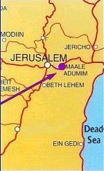
Ma'ale Adumim is located seven kilometers (4.5 miles) east of Jerusalem. This is geographically significant in that it makes Ma'ale Adumim a central location linking the Jordan Valley and Judean Desert to the nation capital, Jerusalem. Historically, foreign powers ruling the area - from the Romans to the Jordanians - attempted to secure this route and considered Ma'ale Adumim strategically crucial to the defense of Jerusalem.

For Ma'ale Adumim maps visit:
jr.co.il/ma/maps.htm
The area boundary of Ma'ale Adumim covers 50 square kilometers
(31 square miles). According to city plans, approximately 10,000 residential units will be constructed in the western zone and 5,000 more residential units will be built to the east of the city's industrial sector, in the Tibek Kuteif area. The industrial sector of Ma'ale Adumim covers an area of 7,750 dunams (1915 acres).
Ma'ale Adumim is surrounded by unique panoramic views. The northern and western views are of the Jerusalem Hills, outstanding among them Mt. Scopus and the Mount of Olives. In the southern and eastern directions, enchanting desert landscapes are visible. From Ma'ale Adumim one is able to see beyond the Jordan River to the mountains of Edom and Moab.
The city area of Ma'ale Adumim at its western boundary is situated 400-450 meters above sea level. The industrial zone and the area to be built east are situated 200-250 meters above sea level.
The name "Ma'ale Adumim" is derived from the book of Joshua
(Chapter 15, verses 6-18), in which Ma'ale Adumim is described as a border area between the tribes of Judah and Benjamin. The name refers to the route leading from the Jordan Valley to Jerusalem, dominated by "reddish hues" in its rock formations.
After the Yom Kippur War, many settlement groups were spontaneously created in Judea and Samaria, one of the most prominent being the Ma'ale Adumim settlement. Organized in Jerusalem, its members spanned a wide socio-cultural and political spectrum. The members worked diligently towards the establishment of a city in Ma'ale Adumim. As a result of their great effort, the Israeli government decided to allow the establishment of a "residential camp" for workers in the area, (know today as "Founders Hill"), and hereon a Jewish settlement developed in the region.
Launched by 23 pioneer families on the seventh night of Chanukah, 1975, Ma'ale Adumim became a local council in 1979. As a result, the settlement received official recognition and now operates within the framework of a municipality. The spirit and determination of these first 23 families paved the way for thousands of others who later followed in their footsteps.
In 1991 the government officially declared Ma'ale Adumim a city.
It is the first Jewish city in Judea, Samaria and Gaza
As of September 2011, the population of Ma'ale Adumim is around 39,000.
Photos of Ma'ale Adumim:
jr.co.il/ma/pic/index.html
Ma'ale Adumim Tourist Sites:
jr.co.il/ma/tourism.htm
Ma'ale Adumim Bus Map (December 2013)
jr.co.il/ma/maale-adumim-bus-map.htm
Links related to Ma'ale Adumim:
jr.co.il/ma/links.htm
|
|
|
|
machat.co.il
|


